
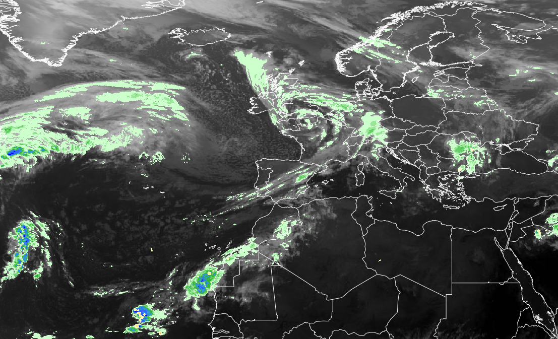
The first named storm of the 2026–27 season threatens Cornwall, Devon and other parts of Britain with damaging winds, coastal hazards and travel disruption.
Storm Austen is bringing a threat of damaging winds, heavy rainfall and widespread travel disruption to parts of the United Kingdom on Friday, October 23, 2026. The first named storm of the 2026–27 season prompted an amber wind warning for Cornwall, the Isles of Scilly and parts of West Devon, with additional warnings covering other areas of England, Wales and Scotland.
The Met Office warned that wind gusts could reach 60 to 70 mph across the hardest-hit areas, with even stronger gusts possible along exposed coastlines. The storm developed over the Atlantic Ocean before moving toward southern Britain late Thursday and into Friday morning.
The combination of severe gales, heavy rain and dangerous coastal conditions has raised concerns about disrupted transportation, falling trees, power outages and local flooding. Emergency services and transportation providers have urged residents to review their plans and monitor official weather updates.
Amber Wind Warning Issued for Cornwall and Devon
The amber wind warning covers all of Cornwall, the Isles of Scilly and parts of West Devon, where the most damaging conditions are expected. The warning runs from 1 a.m. to 10 a.m. Friday, affecting the morning commute and travel along exposed roads.
Devon County Council warned that gusts of 60 to 70 mph were likely for a time, with winds potentially reaching 80 mph on exposed headlands. A wider yellow wind warning extends across parts of southern England and Wales, including sections of the south coast.
The warnings reflect the growing confidence among forecasters about the storm’s strength and likely path. However, the exact location of the strongest winds can still change as a developing weather system moves inland.
The Met Office also issued a yellow rain warning for parts of southern and eastern Scotland. Heavy rainfall could cause standing water, difficult driving conditions and localized flooding, particularly where drainage systems struggle to handle intense downpours.
Why Storm Austen Is Bringing Powerful Winds
Storm Austen developed from an Atlantic low-pressure system strengthened by the jet stream, a fast-moving current of air high in the atmosphere. The jet stream can help weather systems intensify rapidly when atmospheric conditions are favorable.
The Met Office named the storm on October 20 after identifying the potential for significant disruption. At the time, yellow warnings were in place, but forecasters recognized that more serious impacts could develop as the system approached Britain.
Initial forecasts indicated that gusts exceeding 70 mph were possible around particularly exposed coastlines, with 50 to 60 mph winds more widely across affected areas. Rainfall totals of 20 to 30 millimeters were expected in many locations, with higher amounts possible over western hills and other elevated terrain.
Deputy Chief Forecaster Chris Bulmer said the storm could bring particularly disruptive conditions to southwestern England. He emphasized that the combination of strong winds and heavy rain made it important for residents to follow the changing forecasts.
Roads, Rail Services and Ferries Face Disruption
Strong winds could create hazardous conditions on roads across southwestern England, especially for high-sided vehicles and drivers crossing exposed bridges. Fallen branches, debris and surface water may also create dangers during periods of intense weather.
Devon County Council identified the Taw Bridge in Barnstaple and Torridge Bridge in Bideford as locations where temporary closures could become necessary. Officials advised travelers to check for restrictions before leaving home.
Rail services could also be affected because high winds can bring trees and debris onto tracks. Operators may introduce speed restrictions, modify timetables or suspend services when conditions make travel unsafe.
The disruption extends to coastal transportation, where high winds and large waves can make ferry crossings dangerous. Passengers using services to the Isles of Scilly and the Isle of Wight have been advised to check directly with their operators before traveling.
Air travelers using airports in southwestern England may also experience disruption if strong crosswinds or difficult operating conditions affect flights. Individual cancellations and delays depend on local conditions and decisions made by airlines and airport operators.
RNLI Warns of Dangerous Conditions Along the Coast
The Royal National Lifeboat Institution has urged people to take extra precautions near the coast as Storm Austen produces powerful winds and hazardous seas.
Large waves and unexpected surges of water can put people at risk, even when they are standing above the normal shoreline. Beaches, harbors, sea walls and coastal paths may become dangerous during periods of severe weather.
The RNLI advises people to avoid unnecessary risks near exposed shorelines and maintain a safe distance from breaking waves. Those planning coastal activities should pay particular attention to local warnings and changing weather conditions.
The combination of strong winds and rough seas can also complicate rescue operations. Conditions may be especially dangerous around headlands and other exposed locations where waves and wind can intensify.
How the Met Office Weather Warning System Works
The Met Office uses a color-coded National Severe Weather Warning Service to communicate the likelihood and potential consequences of dangerous weather.
A yellow warning indicates that disruptive conditions are possible, although the severity and probability of impacts can vary considerably. Some yellow warnings involve relatively minor interruptions, while others identify the possibility of more serious conditions.
An amber warning indicates an increased likelihood of severe impacts, which may include major travel delays, damage to buildings and infrastructure, and risks to personal safety. A red warning is reserved for situations involving a high likelihood of dangerous conditions and substantial impacts.
Warnings are based on more than wind speed or rainfall totals. Forecasters consider how likely severe conditions are to occur and how significantly they could affect communities, transportation and public safety.
This approach allows warnings to be updated as new forecast information becomes available. Storm Austen demonstrates how an event initially covered by yellow warnings can develop into a more serious weather threat.
Storm Austen Opens the 2026–27 Storm Season
Storm Austen is the first named storm of the current season, which began September 1, 2026, and continues through August 31, 2027.
The storm was named through a joint program involving the UK’s Met Office, Ireland’s Met Éireann and the Royal Netherlands Meteorological Institute. The three organizations maintain a shared list of names to help the public recognize significant storms and understand official warnings.
The name Austen honors Austen Nagle, the first director of the Irish Meteorological Service. He served in that position after the organization was established in 1936.
Storms receive names when they have the potential to cause significant disruption, rather than simply because they reach a particular wind speed. The system is intended to make severe-weather communication clearer across national borders.
More Unsettled Weather Expected During the Weekend
Winds associated with Storm Austen are forecast to gradually ease across southern Britain during Friday afternoon and evening. However, the departure of the storm does not necessarily mean an immediate return to settled weather.
Another Atlantic low-pressure system could bring strong winds to northern parts of the United Kingdom over the weekend. Forecasters indicated that additional weather warnings might be needed for Saturday and Sunday, depending on the system’s development.
Residents in affected areas are encouraged to check the latest official warnings before traveling and to prepare for possible interruptions to electricity and transportation.
The Met Office will continue updating its weather warnings as Storm Austen moves across Britain and the next Atlantic system approaches.
IMAGE: Satellite imagery: EUMETSAT Meteosat, 2026. Source: EUMETSAT Interactive Satellite Viewer (view.eumetsat.int).