
The National Hurricane Center has issued an urgent advisory for Hurricane Milton, which has intensified into a powerful Category 4 hurricane. As of 2 PM EDT, the storm is moving closer to the west coast of Florida, threatening life-threatening storm surges, damaging winds, and torrential rainfall across central and southwestern Florida. With maximum sustained winds of 130 mph (215 km/h) and higher gusts, the storm is expected to make landfall tonight along the west-central coast.
Current Status of Hurricane Milton
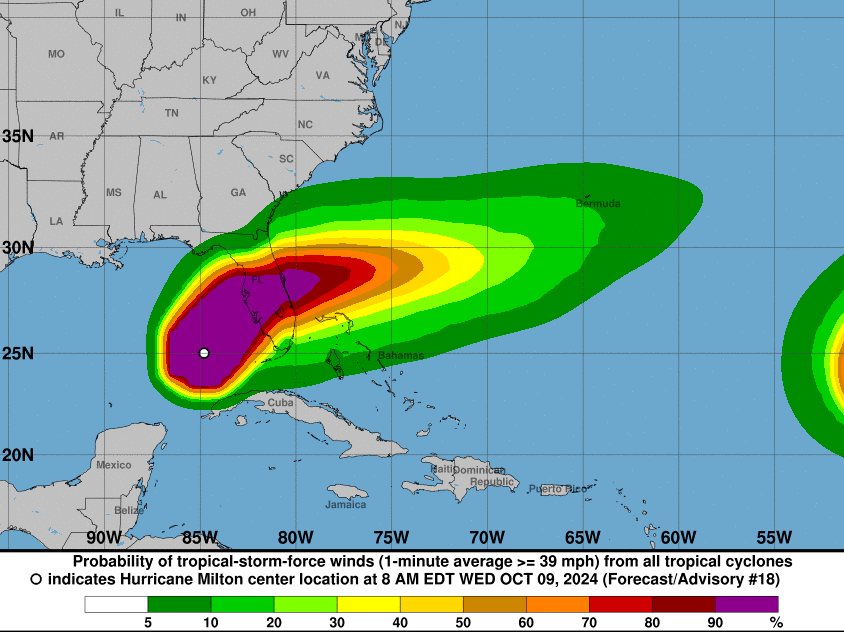
At the 2 PM advisory, Hurricane Milton was located at 26.3°N, 84.0°W, approximately 130 miles west of Ft. Myers and 150 miles southwest of Tampa, Florida. Moving at 16 mph in a north-northeast direction, Milton is expected to slow down later today before taking an eastward turn on Thursday and Friday. After landfall, the storm will cross the Florida peninsula overnight before moving over the Atlantic by Thursday.
Hurricane Milton’s minimum central pressure has dropped to 944 mb (27.88 inches), a clear indication of the storm’s intensity. The storm’s destructive force is widespread, with hurricane-force winds extending up to 35 miles from its center and tropical-storm-force winds extending up to 250 miles. A NOAA saildrone recently reported wind speeds of 52 mph and gusts up to 70 mph, signaling the broad impact the storm will have.
Watches and Warnings in Effect
Several warnings are in effect, urging residents to take immediate action:
- Storm Surge Warning: From Flamingo to Yankeetown on Florida’s west coast, including Tampa Bay and Charlotte Harbor, dangerous storm surge conditions are expected. Surge heights could reach up to 13 feet in certain areas.
- Hurricane Warning: From Bonita Beach to the Suwannee River, including Tampa Bay, hurricane-force winds and flooding are expected. Eastward, a hurricane warning covers the area from the St. Lucie/Martin County Line northward to Ponte Vedra Beach on Florida’s east coast.
- Tropical Storm Warning: Tropical storm conditions are likely across the Florida Keys, parts of the Bahamas, and portions of Georgia and South Carolina. Affected areas should prepare for high winds and flooding.
Residents in the affected areas should heed evacuation orders, as dangerous storm surge and flooding could begin as early as tonight.
Storm Surge and Rainfall
The storm surge poses one of the biggest threats, with water levels expected to rise dramatically. Surge levels could peak at:
- 9 to 13 feet from Anna Maria Island to Boca Grande.
- 8 to 12 feet in Tampa Bay and Charlotte Harbor.
Rainfall totals of 6 to 12 inches are expected across central and northern Florida, with localized areas seeing up to 18 inches. This amount of rainfall could lead to catastrophic flash flooding, river flooding, and widespread urban flooding, particularly in low-lying areas.
Tornadoes and Rip Currents
As the hurricane approaches, there is a heightened risk of tornadoes across central and southern Florida, which could develop tonight. Additionally, dangerous surf and rip currents will continue along the Gulf Coast and southeastern U.S. coasts.
Prepare for Impact
With landfall imminent, residents across the warning areas should finalize preparations. The combination of hurricane-force winds, life-threatening storm surge, and heavy rainfall makes Hurricane Milton a serious threat. Local authorities are urging everyone to follow evacuation orders and prepare for severe weather conditions over the next 36 hours.
Stay updated by monitoring local weather advisories and preparing for power outages, flooding, and potential tornadoes. The National Weather Service will issue its next complete advisory at 5 PM EDT.