
| Listen to our audio presentation: History of the US Supreme Court |
Hurricane Helene is rapidly intensifying as it heads toward Florida, threatening the state with catastrophic winds, life-threatening storm surge, and significant flooding. The National Hurricane Center (NHC) reported that Helene, currently a Category 3 hurricane, is expected to make landfall near the Florida Big Bend late Thursday. It is anticipated to bring sustained winds of up to 155 mph and storm surge as high as 15 feet.
- Hurricane Helene is set to make landfall in Florida as a Category 3 storm, with winds up to 155 mph and a storm surge up to 15 feet in the Big Bend area.
- Tropical storm and hurricane warnings cover the Florida Peninsula, Panhandle, and extend into Georgia and the Carolinas, with heavy rain, flooding, and tornado risks expected.
- Tampa faces a significant storm surge of 5 to 8 feet, while areas inland, including the southern Appalachians, are at risk for flash flooding and landslides.
- Evacuations have been ordered in flood-prone coastal areas, and residents are urged to prepare for widespread power outages and life-threatening conditions.
According to the Orlando Sentinel, the NHC forecasts rapid intensification as Helene moves through the warm waters of the Gulf of Mexico. Winds are already reaching 80 mph, and tropical storm conditions are expected to spread over much of Florida by Wednesday afternoon. Tampa, one of Florida’s major cities, faces a potential ocean surge of 5 to 8 feet, the most severe since the 1980s. Flooding and hazardous conditions are a significant concern across the state.
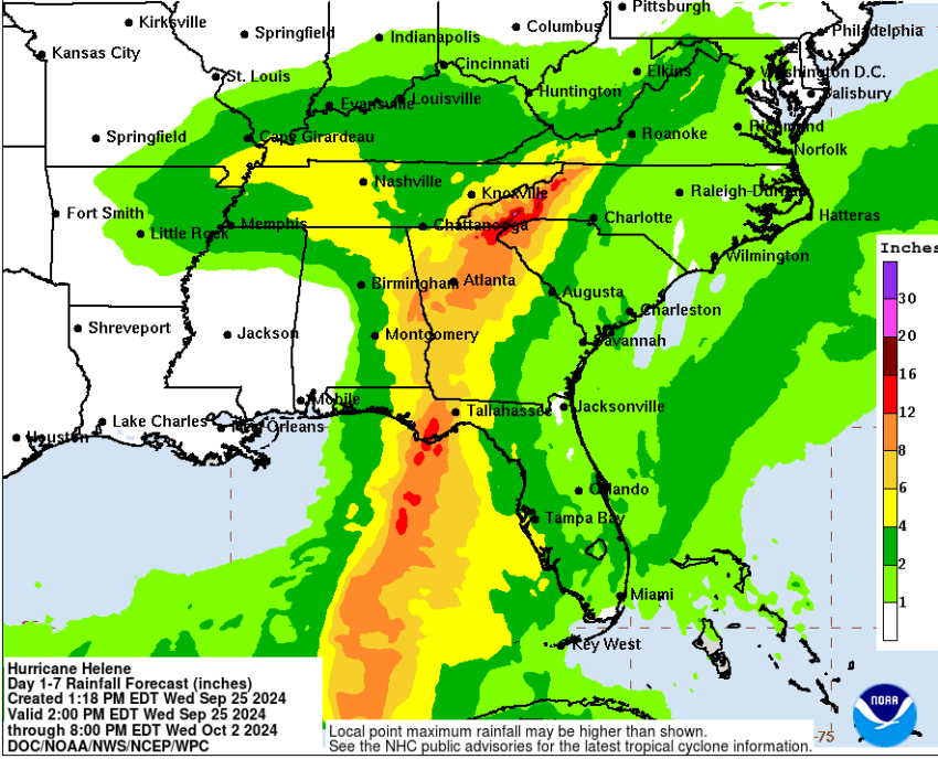
The threat is not limited to Florida’s coastlines. As The Washington Post reports, the storm’s size means its impact will stretch across the Florida Peninsula, the Panhandle, and well into Georgia and the Carolinas. Major population centers, including Atlanta and Nashville, could face heavy rain, winds, and potential flooding. Residents are urged to follow evacuation orders and prepare for widespread disruptions.
In the Big Bend area, where landfall is most likely, residents are bracing for the worst. The NHC has issued hurricane warnings from Tarpon Springs to Mexico Beach, and storm surge warnings are in place across the Florida West Coast. As NPR noted, the Big Bend could see water levels rise 10 to 15 feet above normal. With heavy rainfall predicted to total up to 15 inches in some regions, inland areas also face a significant risk of flash flooding.
The storm surge poses a particularly grave danger, as it threatens to inundate low-lying coastal communities. The NHC’s Robbie Berg highlighted the storm’s unusually large size, warning that even areas far from Helene’s eye could experience dangerous conditions. “Big storms cause big problems,” he emphasized.
Further inland, Fox News reports that Helene will affect parts of the southeastern U.S., including the southern Appalachians, with heavy rain expected to continue through Friday. Areas in the Upper Tennessee Valley may experience flash flooding, and landslides are possible due to the storm’s relentless rain. The NHC has issued tropical storm watches and warnings for parts of Georgia and the Carolinas, as well as the higher elevations of the southern Appalachians.
In preparation for the hurricane, authorities have ordered evacuations for coastal regions. Residents in flood-prone areas are urged to relocate, as storm surge poses a lethal risk. Local officials are advising that anyone in the path of the storm follow evacuation orders and be prepared for extended power outages.
Helene’s fast forward speed also presents a challenge. Once it crosses the coast, strong winds will penetrate inland much farther than usual, potentially affecting areas as far north as Atlanta. The NHC warns that tornadoes may form along the western Florida Peninsula and southern Alabama, adding to the storm’s already considerable dangers.
This hurricane is not one to be underestimated. NBC News pointed out, the storm’s scale and intensity make it a rare and dangerous event, particularly for coastal regions vulnerable to storm surge. While the exact path of Helene could shift slightly, its widespread effects will be felt across much of the Southeast.
As the storm approaches, the NHC continues to provide updated forecasts, urging all residents in the affected areas to stay vigilant. Helene will bring more than just heavy rain and wind—it could reshape Florida’s coastal landscape and disrupt life across the Southeast.