
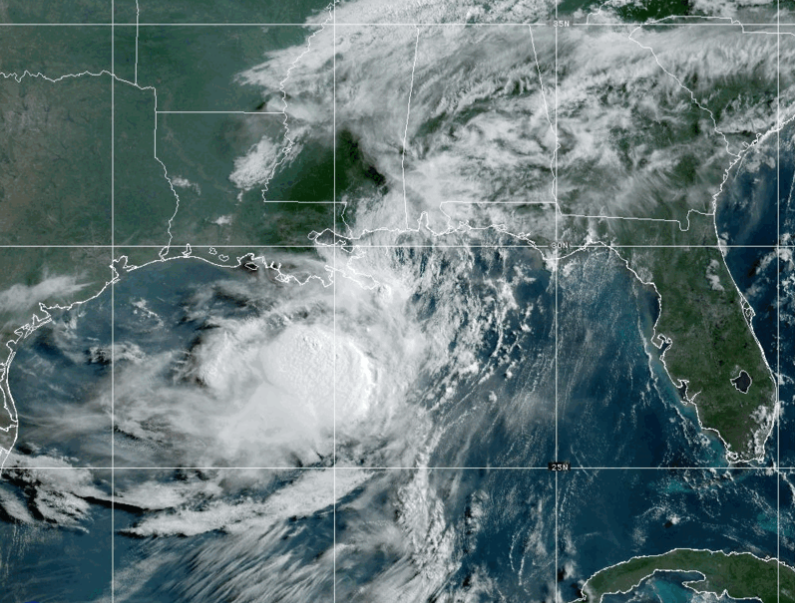
Tropical Storm Bertha made landfall in Southeastern Louisiana early Wednesday morning, bringing up to three feet of storm surge and sustained winds reaching 60 miles per hour. The storm moved westward at a slow pace, continuing near the northern Gulf Coast through Friday with little acceleration. Forecasters noted that Bertha’s path would keep it close to the coast, increasing the risk of coastal flooding and flash floods in areas from western Florida to southern Texas.
The National Hurricane Center reported maximum sustained winds of 50 mph, down from earlier levels, and forecast gradual weakening as the storm progressed. Strong wind shear from the northeast was expected to push the bulk of the weather offshore, reducing rainfall totals and minimizing the potential for severe flooding compared to a slow-moving system. A tropical storm warning was in effect from Florida’s Okaloosa/Walton County Line to Morgan City, Louisiana, including New Orleans and Lake Pontchartrain.
A tropical storm watch remained in place for areas west of Morgan City to Cameron, Louisiana, and Lake Maurepas. Isolated flash flooding was possible across the region, especially in urban environments. The storm brought total rainfall amounts of 1 to 4 inches with some isolated higher totals up to 6 inches through Thursday.
Bertha is the second named storm of the 2026 Atlantic hurricane season, following Tropical Storm Arthur which made landfall in Texas in June. Despite a forecast for fewer storms than average due to strong El Niño conditions, unusually warm Gulf waters increase the risk of stronger storms. Experts warn that even with fewer total storms, the percentage of powerful category 4 and 5 hurricanes has increased over recent decades.
Preparation remains key as residents are advised to have evacuation plans, check insurance coverage, and document valuables ahead of hurricane season. The National Hurricane Center emphasized that while El Niño may reduce the number of storms, it does not eliminate the need for preparedness.
IMAGE: NOAA
22 Jul 2026 – 18:00 UTC …CENTER OF BERTHA APPROACHING THE COAST OF SOUTHEASTERN LOUISIANA… …TROPICAL STORM CONDITIONS CONTINUE TO SPREAD WESTWARD WITHIN THE WARNING AREA… As of 1:00 PM CDT Wed Jul 22 the center of Bertha was located near 29.9, -89.1 with movement WNW at 7 mph. The minimum central pressure was 1000 mb with maximum sustained winds of about 45 mph.
22 Jul 2026 – 15:00 UTC …CENTER OF BERTHA WOBBLING SOUTH OF THE MISSISSIPPI COAST… …TROPICAL STORM CONDITIONS EXPECTED WITHIN THE WARNING AREA THROUGH TONIGHT… As of 10:00 AM CDT Wed Jul 22 the center of Bertha was located near 29.8, -88.6 with movement WNW at 6 mph. The minimum central pressure was 998 mb with maximum sustained winds of about 50 mph.
From NOAA: History of Storm:
22 Jul 2026 – 12:00 UTC …TROPICAL STORM WATCHES EXTENDED WESTWARD ALONG THE EXTREME SOUTHWESTERN LOUISIANA AND UPPER TEXAS COASTS… As of 7:00 AM CDT Wed Jul 22 the center of Bertha was located near 29.5, -88.5 with movement W at 5 mph. The minimum central pressure was 997 mb with maximum sustained winds of about 50 mph.
22 Jul 2026 – 9:00 UTC …BERTHA CONTINUES WESTWARD WITH TROPICAL STORM CONDITIONS EXPECTED TO CONTINUE ALONG THE NORTHERN GULF COAST… As of 4:00 AM CDT Wed Jul 22 the center of Bertha was located near 29.4, -88.3 with movement W at 5 mph. The minimum central pressure was 998 mb with maximum sustained winds of about 50 mph.
22 Jul 2026 – 6:00 UTC …BERTHA MOVING WESTWARD WITH TROPICAL STORM CONDITIONS EXPECTED TO CONTINUE ALONG THE NORTHERN GULF COAST… As of 1:00 AM CDT Wed Jul 22 the center of Bertha was located near 29.3, -87.9 with movement W at 6 mph. The minimum central pressure was 998 mb with maximum sustained winds of about 50 mph.
22 Jul 2026 – 3:00 UTC …TROPICAL STORM CONDITIONS EXPECTED TO CONTINUE SPREADING WESTWARD ALONG THE NORTHERN GULF COAST… As of 10:00 PM CDT Tue Jul 21 the center of Bertha was located near 29.4, -87.7 with movement W at 6 mph. The minimum central pressure was 995 mb with maximum sustained winds of about 60 mph.
22 Jul 2026 – 0:00 UTC …TROPICAL STORM CONDITIONS OCCURRING ALONG PORTIONS OF THE NORTHERN GULF COAST… As of 7:00 PM CDT Tue Jul 21 the center of Bertha was located near 29.3, -87.4 with movement W at 6 mph. The minimum central pressure was 997 mb with maximum sustained winds of about 60 mph.
21 Jul 2026 – 21:00 UTC …TROPICAL STORM CONDITIONS SPREADING WESTWARD ALONG COASTAL PORTIONS OF THE FLORIDA PANHANDLE… …TROPICAL STORM WATCHES AND WARNINGS EXTENDED WESTWARD ALONG THE LOUISIANA COAST… As of 4:00 PM CDT Tue Jul 21 the center of Bertha was located near 29.4, -87.2 with movement NW at 6 mph. The minimum central pressure was 995 mb with maximum sustained winds of about 60 mph.
21 Jul 2026 – 18:00 UTC …BERTHA BEGINNING TO TURN WESTWARD… …TROPICAL STORM CONDITIONS SPREADING OVER PORTIONS OF THE FLORIDA PANHANDLE WITHIN THE WARNING AREA… As of 1:00 PM CDT Tue Jul 21 the center of Bertha was located near 29.3, -86.8 with movement NW at 5 mph. The minimum central pressure was 995 mb with maximum sustained winds of about 60 mph.
21 Jul 2026 – 15:00 UTC …AIR FORCE HURRICANE HUNTERS FIND BERTHA HAS STRENGTHENED… …TROPICAL STORM WATCHES AND WARNINGS REMAIN IN EFFECT FOR PORTIONS OF THE NORTHERN GULF COAST… As of 10:00 AM CDT Tue Jul 21 the center of Bertha was located near 29.3, -86.3 with movement NNW at 3 mph. The minimum central pressure was 995 mb with maximum sustained winds of about 60 mph.
21 Jul 2026 – 12:00 UTC …NOAA HURRICANE HUNTER AIRCRAFT CURRENTLY INVESTIGATING BERTHA… …TROPICAL STORM WATCHES AND WARNINGS REMAIN IN EFFECT FOR PORTIONS OF THE NORTHERN GULF COAST… As of 7:00 AM CDT Tue Jul 21 the center of Bertha was located near 28.8, -86.2 with movement NW at 5 mph. The minimum central pressure was 997 mb with maximum sustained winds of about 50 mph.
21 Jul 2026 – 9:00 UTC …BERTHA RESUMES A NORTHWESTWARD MOTION… …TROPICAL STORM WATCHES AND WARNINGS REMAIN IN EFFECT FOR PORTIONS OF THE NORTH GULF COAST… As of 4:00 AM CDT Tue Jul 21 the center of Bertha was located near 28.7, -86.4 with movement NW at 5 mph. The minimum central pressure was 998 mb with maximum sustained winds of about 50 mph.
21 Jul 2026 – 6:00 UTC …AIRCRAFT AND SATELLITE WIND DATA INDICATE THAT BERTHA IS STRONGER… As of 1:00 AM CDT Tue Jul 21 the center of Bertha was located near 28.4, -86.1 with movement NW at 2 mph. The minimum central pressure was 998 mb with maximum sustained winds of about 50 mph.
21 Jul 2026 – 3:00 UTC …TROPICAL STORM WARNING ISSUED FOR A PORTION OF THE NORTHERN GULF COAST… As of 10:00 PM CDT Mon Jul 20 the center of Bertha was located near 28.2, -85.9 with movement at mph. The minimum central pressure was 999 mb with maximum sustained winds of about 40 mph.
21 Jul 2026 – 0:00 UTC …NOAA HURRICANE HUNTERS FIND THAT THE DEPRESSION HAS STRENGTHENED INTO TROPICAL STORM BERTHA… As of 7:00 PM CDT Mon Jul 20 the center of Bertha was located near 28.6, -86.0 with movement WNW at 3 mph. The minimum central pressure was 1004 mb with maximum sustained winds of about 40 mph.
20 Jul 2026 – 21:00 UTC …DEPRESSION CONTINUES DRIFTING ERRATICALLY NORTHWESTWARD… …AIR FORCE RESERVE AND NOAA AIRCRAFT TO INVESTIGATE IT THIS EVENING… As of 4:00 PM CDT Mon Jul 20 the center of Two was located near 28.7, -85.8 with movement NW at 3 mph. The minimum central pressure was 1005 mb with maximum sustained winds of about 35 mph.
20 Jul 2026 – 18:00 UTC …DEPRESSION DRIFTING ERRATICALLY NORTHWESTWARD… …EXPECTED TO BECOME A TROPICAL STORM THIS AFTERNOON OR TONIGHT… As of 1:00 PM CDT Mon Jul 20 the center of Two was located near 28.6, -85.6 with movement NW at 3 mph. The minimum central pressure was 1005 mb with maximum sustained winds of about 35 mph.
20 Jul 2026 – 15:00 UTC …DEPRESSION GETTING BETTER ORGANIZED… …NEW WATCHES ISSUED FOR PORTIONS OF THE GULF COAST… As of 10:00 AM CDT Mon Jul 20 the center of Two was located near 28.5, -85.6 with movement NW at 3 mph. The minimum central pressure was 1007 mb with maximum sustained winds of about 35 mph.
20 Jul 2026 – 12:00 UTC …DEPRESSION EXPECTED TO BECOME A TROPICAL STORM LATER TODAY… …AIR FORCE HURRICANE HUNTER AIRCRAFT CURRENTLY INVESTIGATING THE SYSTEM… As of 7:00 AM CDT Mon Jul 20 the center of Two was located near 28.6, -85.6 with movement NW at 3 mph. The minimum central pressure was 1006 mb with maximum sustained winds of about 35 mph.
20 Jul 2026 – 9:00 UTC …DEPRESSION EXPECTED TO BECOME A TROPICAL STORM LATER TODAY… …TROPICAL STORM WATCH EXTENDED TO MISSISSIPPI/ALABAMA BORDER… As of 4:00 AM CDT Mon Jul 20 the center of Two was located near 28.5, -85.4 with movement NW at 3 mph. The minimum central pressure was 1006 mb with maximum sustained winds of about 35 mph.
20 Jul 2026 – 6:00 UTC …DEPRESSION CONTINUES DRIFTING NORTH-NORTHWESTWARD… As of 1:00 AM CDT Mon Jul 20 the center of Two was located near 28.4, -85.3 with movement NNW at 3 mph. The minimum central pressure was 1007 mb with maximum sustained winds of about 30 mph.
This article passed automated originality and source-verification checks before publishing.