
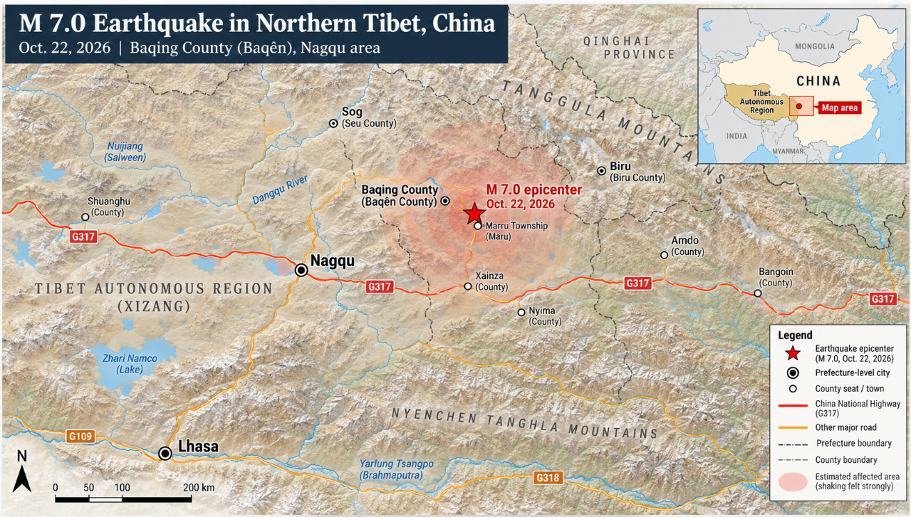
A magnitude 7.0 earthquake struck Baqing County in northern Tibet, killing at least 16 people, injuring 65 and damaging hundreds of homes.
At least 16 people were killed and 65 injured after a magnitude 7.0 earthquake struck Baqing County in northern Tibet late Thursday, triggering building collapses and a large emergency response across the high-altitude region.
The earthquake struck at 10:33 p.m. local time on October 22 in Baqing County, part of Nagqu in the Tibet Autonomous Region. Chinese authorities placed the epicenter at 32.40 degrees north and 93.79 degrees east, with a depth of 10 kilometers. The U.S. Geological Survey also measured the quake at magnitude 7.0 but estimated a depth of about 18 kilometers and placed the epicenter roughly 191 kilometers east-northeast of Nagqu.
Death Toll Rises as Rescue Teams Reach Damaged Villages
Officials initially reported 32 injuries shortly after rescue teams began reaching damaged communities. That number rose to 46 by early Friday and later to 65 injured as crews continued checking villages and treating survivors. Eleven of the injured were listed in serious condition, while 54 had minor injuries, according to the latest figures from the Nagqu earthquake relief command.
Authorities said 339 households had homes that collapsed or were damaged. Twenty livestock shelters were also damaged. The earthquake struck a sparsely populated section of the Tibetan Plateau where elevations are high and settlements are spread across a wide area, making nighttime rescue work more difficult.
Some of the strongest damage was reported around Maru Township, which lies close to the epicenter. Earlier reports described cracked walls, collapsed homes and damaged roads. Rescue workers reached villages during the night and pulled at least one trapped person from a collapsed building.
By Friday morning, more than 12,000 people had been moved to safer locations as authorities continued door-to-door checks and emergency shelter operations. Tents, folding beds, quilts, stoves and other supplies were transported toward the earthquake zone.
Emergency Response Expands Across Northern Tibet
China’s earthquake authorities activated emergency response measures soon after the quake. The national earthquake disaster response was later raised from Level IV to Level III as the scale of casualties and damage became clearer. Firefighters, police, medical teams, military personnel and other emergency workers were sent toward Baqing County.
More than 300 military and armed police personnel were deployed with vehicles, while aircraft and drones were used to inspect the affected area from above. Rescue crews also carried thousands of pieces of equipment and emergency supplies into the region.
Transportation officials inspected highways, bridges and culverts after reports of cracks and rockfalls. National Highway 317, an important route across the Tibetan Plateau, was affected in some areas, and authorities imposed traffic controls while crews checked for hazards. Railway officials also inspected infrastructure after the earthquake.
Power and communications were disrupted in some places immediately after the shaking. Later reports said electricity in Baqing County and communications in heavily affected communities had largely been restored. Officials said roads in the wider Nagqu area remained usable as rescue convoys continued moving toward the epicenter.
Why the Tibetan Plateau Experiences Powerful Earthquakes
The earthquake occurred within the Tibetan Plateau, one of the world’s most seismically active continental regions. The plateau is shaped by the continuing collision of the Indian and Eurasian tectonic plates. That collision has thickened and uplifted the crust, while parts of the plateau are also being stretched from east to west.
Seismologists said the Baqing earthquake was associated with an extensional, or normal-faulting, rupture. Chinese earthquake experts said the epicenter was close to the Baqing-Leiwuqi fault and warned that additional felt aftershocks were possible.
By Friday morning, hundreds of aftershocks had been recorded, although only a smaller number were magnitude 3.0 or greater. The strongest reported aftershock was magnitude 4.3. Authorities warned residents and rescue teams to remain alert for further shaking, landslides and other secondary hazards.
The cold and thin air of the high plateau added another challenge. Chinese officials emphasized the need to provide shelter and heating to displaced residents because nighttime temperatures can fall sharply at high elevations. The affected area lies at an average elevation of roughly 4,800 meters (15,700 feet), according to Chinese state reporting.
Recent Flooding Adds to Regional Disaster Concerns
The earthquake also came less than two months after catastrophic flooding struck parts of Nepal and Tibet near the China-Nepal border. Those floods followed a glacier collapse in late August and caused severe damage far southwest of the Baqing earthquake zone. More than 900 people had been confirmed dead by the end of August, while thousands remained missing at that stage of the search.
The two disasters occurred in different parts of the Himalayan and Tibetan region and should not be treated as one continuing event. Officials had not reported evidence that Thursday’s earthquake directly affected communities damaged by the August flooding.
Damage Assessments and Aftershock Monitoring Continue
Baqing County sits hundreds of kilometers from Lhasa, Tibet’s regional capital. Nagqu itself lies more than 300 kilometers north of Lhasa, and the earthquake’s remote location limited the number of large population centers exposed to the strongest shaking.
The full extent of structural damage was still being assessed Friday. Rescue teams continued searching damaged homes, treating the injured and moving residents into temporary shelters while officials monitored aftershocks and weather conditions across the earthquake zone.
IMAGE: DNR Art Department