
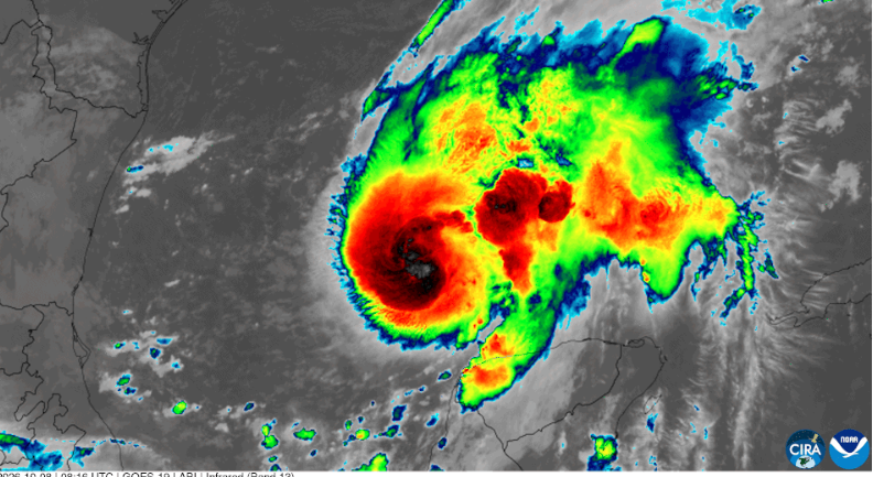
The Category 2 hurricane struck near Destin, Florida, with 105 mph winds. Isaias has weakened, but flooding, power outages and damaging winds remain a threat across the Southeast.
Hurricane Isaias struck the Florida Panhandle late Friday as a powerful Category 2 storm, bringing damaging winds, storm surge and heavy rain before pushing north into Alabama. By Saturday afternoon, the system had weakened into a post-tropical cyclone, but flooding, strong wind gusts and scattered tornado risks were still affecting parts of the Southeast.
The National Hurricane Center said Isaias made landfall near Destin, Florida, at about 8:30 p.m. Central time Friday with maximum sustained winds of 105 mph. A weather station near Santa Rosa Sound recorded a gust of 116 mph, while Panama City Beach saw water rise about 5.6 feet above the normal high-tide level.
At least four deaths had been linked to the storm by Saturday. Two people were killed when trees fell onto homes, while another death in Florida was blamed on carbon monoxide poisoning from a generator being used in a garage. Alabama officials also reported a fatal vehicle crash involving a downed tree.
Hundreds of thousands of homes and businesses remained without electricity across Florida, Alabama, Georgia and Mississippi. PowerOutage.us reported more than 600,000 customers without service across those four states Saturday afternoon, after outages approached 900,000 in the first hours after landfall.
Florida remained the hardest-hit state. Gov. Ron DeSantis said more than 16,000 utility workers and restoration personnel had been positioned before the storm. State officials said roughly 439,000 Florida customer accounts were still without power early Saturday afternoon as crews began clearing roads and repairing damaged lines.
Damage was scattered across the western Florida Panhandle. The storm tore roofing and exterior materials from buildings, uprooted trees and damaged power infrastructure. Pensacola International Airport was closed to commercial flights after sustaining storm damage, while local officials also reported concerns about drinking-water supplies.
Residents in Destin, Gulf Breeze, Milton, Pensacola and other communities emerged Saturday to find downed trees, damaged roofs and debris scattered across streets and parking lots. Some coastal structures were heavily damaged, including a collapsed boathouse in Destin. Crews began assessing buildings and clearing major roads as winds eased.
The storm had weakened sharply by Saturday morning as it moved inland. The National Hurricane Center classified Isaias as post-tropical at 4 a.m. Central time, ending tropical storm and storm surge warnings along the Gulf Coast.
The danger did not end with the loss of hurricane status.
At 4 p.m. Central time Saturday, the Weather Prediction Center placed the center of post-tropical Isaias about five miles west of Birmingham, Alabama. Maximum sustained winds were about 30 mph, and the system was moving north-northeast at 15 mph.
Forecasters warned that heavy rain could still cause flash and urban flooding across parts of the Southeast and southern Appalachians. Saturated ground also increases the risk that trees can fall in gusty winds. Landslides were possible in mountainous areas where the remnants of Isaias were expected to produce additional rainfall.
Strong wind gusts continued across Alabama and nearby states during the day. The National Weather Service in Birmingham warned that gusts could still reach 40 to 50 mph in parts of central Alabama. Flood watches also remained in effect in parts of the region.
A tornado threat extended farther east. Federal forecasters said a couple of tornadoes were possible Saturday across eastern Georgia and the Carolinas as bands of unstable weather moved around the remnants of Isaias.
The storm also disrupted Gulf of Mexico energy production. Reuters reported that about 69 percent of Gulf oil production and 57 percent of natural gas production remained shut Saturday. Shell and Chevron were beginning to return workers to offshore facilities as conditions improved.
The U.S. Department of Energy authorized an emergency exchange of as much as 4 million barrels of crude oil from the Strategic Petroleum Reserve. The department said ExxonMobil and BP America could each receive up to 2 million barrels to help address supply disruptions caused by the hurricane. The companies are required to return the oil later with additional barrels.
President Donald Trump approved emergency declarations for Florida, Alabama and Georgia, allowing federal resources to support state and local response efforts. Officials continued damage assessments Saturday as power crews, emergency teams and transportation workers moved into affected communities.
Isaias was the first hurricane of the unusually quiet 2026 Atlantic hurricane season. The late arrival was remarkable: the Atlantic did not produce its first hurricane until October 8, nearly matching the latest first-hurricane date in more than a century of records. A strong El Niño has helped suppress Atlantic storm development by creating atmospheric conditions that make it harder for tropical systems to organize.
Even so, Isaias intensified quickly once conditions became favorable over the Gulf. It reached Category 3 strength for a time Friday, with maximum sustained winds of 120 mph. The storm weakened before landfall, but its 105 mph winds still placed it well within Category 2 strength when the center crossed the Florida coast.
The storm’s inland path will remain important through the weekend. Forecasters expect the remnants to move through the Tennessee Valley and toward the central Appalachians before weakening further. Flooding, falling trees and damaged power lines remain the main threats along that route.
For people in areas affected by the storm, officials are warning against driving through flooded roads or approaching downed electrical lines. Generators should be operated outdoors and well away from homes, garages, doors and windows because carbon monoxide can build up quickly in enclosed spaces.
Along the Gulf Coast, dangerous surf and rip currents may continue even after the center of Isaias moves farther inland.
Recovery work in Florida and Alabama is expected to continue for days as crews restore power, reopen damaged facilities and determine the full extent of the storm’s losses.
IMAGE: Source NOAA’s GOES East Satellite Monitors Hurricane Isaias Author NOAA CC0